Since 1931, Portland has been a town of quadrants: Northeast, Southeast, Northwest, Southwest, and North, which didn’t fit but was still the fifth “quadrant”. At the time, few people lived in the area now called “South” so it just became a part of Southwest. In 2006, several Southwest Portland neighborhoods banded together and called themselves “South Portland” but it was, by no means, official.
In 2018, however, the city council and the Portland Bureau Of Transportation (PBOT) decided that a sixth area be added to the street designations. The reasoning was that many addresses in the Southwest actually began with a 0 because buildings were erected after the address numbering had stopped. This was causing confusion and delay for deliveries and, more importantly, emergency response units.
According to PBOT, the “former area of Southwest Portland east of SW Naito Parkway and SW View Point Terrace. Due to the eastward curvature in the Willamette River, east-west addresses in this area were previously addressed with a leading zero address to differentiate them from addresses west of this dividing line. About 8% of Southwest Portland addresses prior to the creation of South Portland were in this leading zero addressing area.”
Per the city’s Public Broadcasting Station, OPB “The new South Portland occupies a strip of land shaped like a pointer finger along the west bank of the Willamette River.
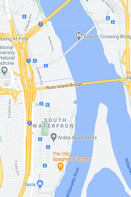
The area includes roughly 10,000 addresses and properties in the South Waterfront, Collins View and Riverdale neighborhoods…The river is the eastern boundary of the South District, while Southwest Naito Parkway and the Tryon Creek State Natural area are the western boundary.”
The Pamplin site points out that “Two major institutions are affected. Oregon Health & Science University South Waterfront outpost will be at 3301 S. Bond Ave. rather than Southwest Bond Avenue. Lewis and Clark College will no longer be found at 0615 S.W. Palantine Road, but at 615 S. Palantine Road.
Along the banks of the Willamette, several high end, high rise condominium complexes have been affected by the change, as well as diverse residential neighborhoods to the south. The entire South Waterfront district is now in South Portland.
Starting in May 2020, the city’s addressing plan will take the next five years to switch out all of the street signs in question. All applicable street signs marked Southwest will be replaced by 2025. The US Postal Service will still deliver mail to those affected by the address change, even if they use the old numbering system.
“This will probably not stop many Portlanders from referring to this area as the sixth “quadrant” of the city, even though a quadrant signifies one of four parts. It’s a designation that the Portland Bureau of Transportation acknowledges.
“Many Portlanders do prefer to call the city’s address areas quadrants regardless of the total number,” the agency announced in a press release. “In this spirit, PBOT will also informally recognize sixth quadrant as a designation for the new part of the city,” states Oregon Live the website for Portland’s newspaper, The Oregonian.